


les Orres le pic vert

orsel
User GUIDE
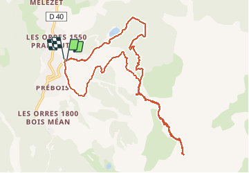

Length
11.6 km

Max alt
2660 m

Uphill gradient
997 m
Km-Effort
25 km

Min alt
1657 m

Downhill gradient
1007 m
Boucle
Yes
Creation date :
2021-03-14 08:06:19.636
Updated on :
2021-03-14 14:57:53.212
4h53
Difficulty : Medium

FREE GPS app for hiking
 SityTrail
IGN / Geographical institutes
SityTrail Plus
The world is yours!
About
Trail Touring skiing of 11.6 km to be discovered at Provence-Alpes-Côte d'Azur, Hautes-Alpes, Les Orres. This trail is proposed by orsel.
Positioning
Country:
France
Region :
Provence-Alpes-Côte d'Azur
Department/Province :
Hautes-Alpes
Municipality :
Les Orres
Location:
Unknown
Start:(Dec)
Start:(UTM)
305842 ; 4929718 (32T) N.
Comments